


saltyvagabonds
Saltyvagabonds
Destinations

Asia
Bali
Japan
Korea
Malaysia
singapore
Thailand
Vietnam
Europe
Germany
France
U.K.
North America
Canada
Mexico
Oceania
Polynesia
Micronesia
Hawaii
Guam
Indonesia
All Travel Blogs
Travel Tips
Planning
About us
usa
Destinations
Travel Tips
Planning
About us
All Categories
Travel Tips
Worldschooling
Digital Nomad
Travel Hacking
Travel with kids
Lifestyle
Military Travel
Packing
All Travel Tips
Tech


Travel Hacking with
Chase Points
Military Space A Flights
Guide


The WWII Guns at Faanui: Bora Bora’s Free Cannon Hike Most Tourists Skip
Two WWII-era cannons are still sitting in the jungle above Bora Bora’s lagoon entrance. No tour, no fee, just a free one-mile hike and a view most tourists never see.

If you click on links we provide, we may receive compensation.


The Edit: This post covers the free hike to the WWII guns at Faanui in Bora Bora, where two US Navy cannons installed during World War II still sit in the jungle above the island’s inner lagoon entrance. The route is on private property owned by the Bora Bora Activity Center, but hikers are welcome, just ask if anyone is around. This guide covers where to park, how to navigate the trail, what you’ll find at the top, and why you don’t need to book a paid tour to see them.

A Cannon Hike Nobody Puts on Their Itinerary
Most people who come to Bora Bora never know these cannons exist. They book the lagoon tour, they find their overwater bungalow, they photograph Mount Otemanu from every possible angle and they leave without ever knowing that many WWII-era guns are sitting in the jungle less than a mile up the hill, right where the US Navy put them nearly 80 years ago.
The Bora Bora WWII cannons, sometimes called the WWII guns at Faanui or Chemin des Cannons, are part of a larger network of fortifications the US military built across the South Pacific during World War II.
Bora Bora was actually a key American base in the Pacific, used as a refueling and supply stop for Allied forces. The island’s strategic position made it important enough to arm heavily, and the cannons positioned above the lagoon entrance are what’s left of that.
I almost drove past the trailhead twice before I found it. The road leading up looks exactly like a private driveway, because it is. But once I figured out where I was going, it turned out to be one of the best free things you can do on the island.

Finding the Trailhead
The hike starts on the perimeter road, the single road that circles the main island. Look for the Bora Bora Activity Center, a house and shop-style building right on the road with a dock and jet skis out front. That’s your landmark.
Most people simply park along the road across from the driveway, under the coconut palms, before heading uphill, and that’s exactly what we did. The road leading up is easy to miss because it looks like someone’s driveway. If you drove the island the day before like we did, it helps to slow down in that area and identify it ahead of time so you’re not guessing on the day.

Asking Permission
When I pulled up, there were four guys in a truck getting ready to leave the gravel lot. I waved, walked over, and asked if it was okay to hike up to the cannons. The two guys in the front seat didn’t speak much English, so the driver turned around asked someone in the back seat to respond.
They confirmed it’s private property but said hikers are welcome to walk up. What they told me next is worth paying attention to: do not go left at the junction. A lot of people get lost going that direction, and they wanted me to know before I headed up. They also asked if I had a map, which I did, AllTrails and Strava both pulled up, phone at 100%.
The business is the Bora Bora Activity Center, which runs jet ski and ATV rentals out of that spot. If someone is around when you show up, just take 30 seconds to check in with them. They’re friendly about it.

The Hike Up
The hike starts immediately with a steep climb up a gravel road. Within about 20 feet, the road briefly becomes paved as you pass two homes terraced into the hillside. After a short climb, you’ll hit a switchback. Past the homes, the pavement ends and the road transitions back to gravel and volcanic rock.
From here it feels more like a Forest Service road or ATV track than a hiking trail. You’ll be pushing through thick jungle vegetation with jagged volcanic rock underfoot. The incline is steady but manageable, sitting somewhere around a 6–8% grade.
About 200–300 feet past the switchback, another road branches off to the right. It likely leads to homes further up the ridge. A silver truck came down from that direction while I was heading up. Just stay on the main uphill road and ignore it.
From there the road levels out slightly, dips down, and then climbs again. Along the way you might run into ATVs running tours, workers clearing back the vegetation with machetes (rainy season means fast growth out here), and wild chickens wandering around like they own the place. They pretty much do.

Junctions and Navigation
At roughly half a mile to three-quarters of a mile in, you’ll hit the most confusing part of the hike. The road opens up into what looks like three possible directions: left, middle, and right. There’s also a smaller branch to the right that appears just before the main junction, which makes it feel even more complicated than it is.
Take the middle road. It’s usually the most worn-looking option and will keep you on track toward the Bora Bora WWII cannons.
The left road is the one that trips people up. It climbs higher toward the mountain and is where hikers sometimes end up lost trying to find viewpoints or attempting the Mount Pahia summit on their own. I’ve heard this from the property owner and from our Airbnb host independently. If you want to go that direction, its best to hire a guide.
After doing the Mount Mata Pupu summit separately, I’d agree, some of these upper routes can get genuinely dangerous, and there’s no search and rescue infrastructure here on Bora Bora beyond the standard fire station and police station.

The Final Stretch to the Cannons
Past the junction, the trail meanders along the hillside with a few small side paths branching off. Those are likely ATV bypass routes so tour groups coming from opposite directions don’t block each other, the trail is only about as wide as an ATV, so it makes sense.
The trail dips down through a section carpeted in ironwood pine needles, gets a little muddy, and then climbs back up. More chickens. Then a small concrete structure comes into view around a corner, and right behind it, the back end of the first cannon.
It’s closer than you expect. The whole thing is about a mile in, maybe a 20–30 minute walk if you’re moving at a steady pace.


The WWII Guns at Faanui
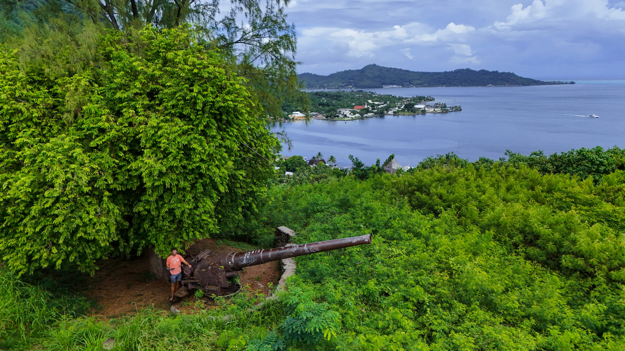
There are two cannons up there, both sitting under ironwood trees with workers clearing the vegetation around them when I visited. They’ve been up here since World War II, almost 80 years, and the jungle has done its best to take them back.
The first cannon faces roughly south to southeast, positioned to cover the entrance to Bora Bora’s inner lagoon. From up there you can see straight down to the shark and stingray encounter area. It’s easy to picture why this position mattered, anyone trying to enter the lagoon would have been in direct line of fire.
The second cannon faces north toward the west side of the island, with views out toward Le Bora Bora resort, the overwater bungalows, the blue lagoon, and the mountain peaks rising behind everything. The cruise ship dock is visible from up here. The cargo pier disappears behind the foliage.
Near the cannons there’s also a small WWII-era concrete bunker worth poking around before you head back. A road makes a small loop near the cannons that connects back to the same trail, so you can do a little circle rather than just standing in one spot.
This is a legitimately good content spot if you’re shooting photos or flying a drone. The views are wide and the history gives you something real to work with.

The Hike Down
Same route in reverse, nothing complicated. About halfway down the sun broke through and the whole island opened up with blue skies, green jungle and the lagoon below. One of the workers was out near the road on the way out and I waved goodbye. That was about it.
Trail Stats
| Stat | Details |
|---|---|
| Distance | 1.80 mi |
| Elevation Gain | 514 ft |
| Moving Time | 51:54 |
| Steps | 4,606 |
| Calories | 315 |
You Need to do the The WWII Guns at Faanui Hike
The Bora Bora WW2 cannons are one of those things that make you feel like you actually found something. Not a tour, not a resort amenity, not something printed on a flyer at the front desk, just a real piece of history sitting in the jungle that most tourists drive right past.
It’s free. It’s easy enough for families. It takes less than an hour round trip. And when you’re standing up there looking down at the lagoon entrance, you get a completely different view of the island than you’ll find anywhere else.
If you’re already renting a car and circling the island, there’s no reason to skip it.


| Quick Facts | Detail |
|---|---|
| Location | Faanui, Bora Bora, French Polynesia |
| Trail Name | WWII Guns at Faanui (AllTrails) |
| Distance | ~1 mile each way |
| Elevation Gain | Moderate, steady climb |
| Estimated Time | 20–30 minutes up, same down |
| Difficulty | Easy to moderate |
| Cost | Free |
| Property | Private (Bora Bora Activity Center) — hikers welcome, ask permission |
| Best For | Budget travelers, families, history buffs, anyone skipping the paid tour |
| Trail Conditions | Can be muddy in rainy season |
| Bring | AllTrails or Strava map, fully charged phone, water |
A Few Things Worth Knowing
∙ Do not go left at the main junction. Seriously. People get lost up there.
∙ Bring a map. AllTrails and Strava both work, keep your phone charged.
∙ Ask permission if anyone from the Bora Bora Activity Center is around when you arrive.
∙ Pack out whatever you bring in. Don’t pick fruit or take anything from the property.
∙ The trail gets muddy in rainy season. Wear shoes you don’t mind getting dirty.
∙ It’s ATV-width the whole way, not a manicured hiking trail. Adjust expectations accordingly.
More Bora Bora Hikes Worth Adding to Your List
- Hiking in Bora Bora: Free Self-Guided Trails, Ridge Views, and When You Need a Guide
- Valley of the Kings Bora Bora: Finding the Sacred Banyan Tree Solo
- Mount Mataihua Hike Bora Bora: The Rope-Assisted Ridge Climb Most Visitors Never Attempt
- The WWII Guns at Faanui: Bora Bora’s Free Cannon Hike Most Tourists Skip
- Hiking Mount Mata Pupu in Bora Bora: A Short Ridge Hike With Incredible Lagoon Views
- Hiking Arete de Matira in Bora Bora: A Family Friendly Ridge With Incredible Views


Leave a Reply


Planning
Tips
Destinations
Oceania
North America
Europe
Asia
Bali
Japan
Korea
Malaysia
singapore
Thailand
Vietnam
France
U.K.
Germany
Canada
Mexico
usa
French Polynesia
Micronesia
Hawaii
Guam
Indonesia
All Travel Blogs
Destinations
Planning
Tips
Destinations
Travel Tips
Planning
About us
Hotels
via Booking.com


Car Rental
Book a Bus/Train/Transfer
Find Cheap Flights
Get ESIM or SIM Card
Easy Currency Exchange
Book Tours & Attractions
Get Travel Insurance
via Discover Cars
via Skyscanner
via 12Go
via Wise
via Viator
via Visitors Coverage
via SimOptions
Destinations
Planning
Tips
All Categories
Travel Tips
Worldschooling
Digital Nomad
Travel Hacking
Travel with kids
Lifestyle
Military Travel
Packing
All Travel Tips
Tech
