


saltyvagabonds
Saltyvagabonds
Destinations

Asia
Bali
Japan
Korea
Malaysia
singapore
Thailand
Vietnam
Europe
Germany
France
U.K.
North America
Canada
Mexico
Oceania
Polynesia
Micronesia
Hawaii
Guam
Indonesia
All Travel Blogs
Travel Tips
Planning
About us
usa
Destinations
Travel Tips
Planning
About us
All Categories
Travel Tips
Worldschooling
Digital Nomad
Travel Hacking
Travel with kids
Lifestyle
Military Travel
Packing
All Travel Tips
Tech


Travel Hacking with
Chase Points
Military Space A Flights
Guide


Valley of the Kings Bora Bora: Finding the Sacred Banyan Tree Solo
James Cameron sat under this tree for two hours and it ended up in Avatar. I spent a full day fighting through mud and dead ends in a Bora Bora jungle to find it.

If you click on links we provide, we may receive compensation.


THE EDIT: The Valley of the Kings hike in Bora Bora, locally known as the Faanui Marae trail, leads into the oldest settled valley on the island and is home to an ancient Marae temple site, a massive sacred banyan tree known as Tumu Ora, and royal burial grounds dating back centuries. This post documents one solo attempt to find the banyan tree without a guide, including the route, the dead ends, what you’ll actually encounter on the trail, and why booking a guide is the honest recommendation for anyone who wants the full cultural experience. If you are searching for the tree on your own, this is the most detailed account in English you are going to find.

Why I Went Looking for the Valley of the Kings
Most people who visit Bora Bora never make it to Faanui. They stay on the motu resorts, do a lagoon tour, maybe hike up toward Matira or the cannons. The Faanui valley is on the opposite end of the island, tucked behind the oldest village on Bora Bora, and unless you go looking for it, you would never know it exists.
What’s up there is unlike anything else on the island. An ancient Marae, which is a sacred Polynesian temple and ceremonial site. A sacred banyan tree called Tumu Ora, the Tree of Life, which is believed to be one of the largest in all of French Polynesia. Royal burial grounds where the kings of Bora Bora were laid to rest, their bodies placed upright inside the roots of the banyan and slowly absorbed by the tree over time. A petroglyph carved into stone representing Bora Bora itself and the Tahitian god of creation.
James Cameron reportedly spent two hours sitting quietly at this tree while researching Avatar. The connection between the hair and the roots, the tree as a living link between people and the land, the entire concept made it into the film.
I had been up in the general direction before on the Mount Mataihua hike, where you can actually see the banyan tree area from the summit. I knew it was up there. I just needed to find the entry point.
The problem is that almost nothing useful exists online about how to actually get there on your own. Bora Bora Insider has a beautiful write-up but it reads like a guided tour recap, not a hiking guide. The Four Seasons lists it as a curated experience. AllTrails has a route named Faanui Marae but following it on the ground is a different story entirely.
So I went on a Saturday after two and a half days of nonstop rain, with two water bottles, Chaco sandals, long pants because I had read about overgrown brush, and my phone at 100 percent. No snacks. This was that kind of day.

Getting to Faanui and Where to Park
The Faanui valley is on the northwest side of the island. From Vaitape, you follow the main perimeter road north past the cannons and the American WWII gun emplacements, past the airport ferry dock, and into the village of Faanui. You will know you are in the right area when you see the church and the large covered gymnasium slash basketball court next to it.
Park in the lot in front of the church. It is a real lot, not a roadside pull-off, and it is the same parking area used for the Mount Mataihua hike. There are usually a few locals around, sometimes selling avocados or other produce from the back of a truck.
This is where the straightforward part of the day ends.
Three Dead Ends Before I Found Anything
I want to be honest with you about what this hike is actually like without a guide, because nothing I read before going prepared me for it.
Dead End Number One: The Covered Gymnasium Road
The AllTrails map shows a route that heads up the road next to the covered gymnasium. I followed it. The road climbs, passes a couple of homes terraced into the hillside, and then essentially ends at someone’s yard. There was a guy hanging out, music playing, completely unbothered by my presence. But the trail just kind of dissolved into his driveway. There was a house farther up on a higher terrace but no clear path to it and no indication I was welcome to keep going. I turned around.
Dogs everywhere in this section, which is a theme throughout this whole hike. One barks, they all bark. Just keep moving, do not engage, you will be fine.
Dead End Number Two: The Tsunami Evacuation Route
Back on the main road heading in the direction I had come from, I spotted a tsunami evacuation route sign. Evacuation roads in Bora Bora are usually paved, wider, and go higher than a regular driveway, so I followed it up. There is a guy on a scooter partway up who was moving pretty slowly and not super communicative, but I tried to ask if the road went toward the banyan tree. He pointed me toward the cannon hike area, way down the road in the other direction. That was not what I was looking for, so I turned around again.


Dead End Number Three: The Water Tower Road
From there I went back toward the church, took the immediate right past it, and headed up toward the ridge traverse road, the same one that connects to the Mount Mataihua route. I went past where you would branch off toward Mataihua and followed a road back toward the water tower. There is a sign up there that I had seen before warning hikers not to attempt certain upper routes without a guide.
I met a local guy at this point who was up there with his kids collecting avocados off a tree with a long bamboo pole. We talked for a bit. He offered me a smoke, I passed, and we chatted about where I was trying to go. He said he might take me up after he was done, pointed me toward a gravel road and said basically just go through the woods. He also handed me three avocados, which was generous and which I would end up carrying through mud, boulders, and off-trail jungle for the rest of the day.
I went up, hit a dead end with four dogs barking, turned around. He was still there when I came back down. He mentioned Django Edwards by name as the person who really knows this hike. I filed that away. There is also a sign up near the water tower warning hikers not to attempt the upper Pahia routes without a guide, which felt increasingly relevant as the day went on.
At this point I had already walked close to three miles and gone through most of my first water bottle.

How I Actually Found the Trail
I was about to call it when I decided to walk down a paved road I had been eyeing. The map showed a small trail that offshots from the paved road directly into the woods toward the Marae site. I walked past the house first, then came back to look more carefully.
A small sign partway down the driveway said something like Attention, and two guys were working on a house being built on the property. I walked up, made eye contact, asked in English if I could pass through to find the banyan tree. Their English was limited but they understood banyan tree. They pointed me through and said just go up.
The actual entry point to the trail is a small opening off the driveway, maybe wide enough for a four-wheeler, that cuts into the woods. Easy to miss because the entry is not maintained. No machete work, no weed-eating, just tall grass at the mouth of it that blends into the surrounding vegetation. If you are not looking for it specifically you will walk right past it, which is exactly what I did the first time.
That is the honest answer you get from everyone in Faanui. Just go up.
Past their property there is an actual path. It does show up on both AllTrails and Strava, and if you look at the Strava heat map you can see real activity data on the exact route up to the Marae and the banyan tree. The problem on the day I was there was that my phone was connecting to an international cell tower and loading data slowly, so I could see the route existed but could not get it to render clearly enough in real time to follow it confidently.
If your data connection is solid you are in better shape than I was. The path itself is not maintained with markers or signage, but it is a real footpath through the jungle that people clearly use. Muddy from two and a half days of rain, flanked by trees and thick vegetation, but walkable.
What the Trail Is Actually Like
The path climbs through mud and tree roots past areas where locals are clearly harvesting coconuts and other crops. After a while it opens into a flatter section with boulders. The vibe shifts here. The vegetation changes, the light changes, and you can feel that you are in a different kind of place.
This is the area near where the Marae is supposed to be. I walked through it. I saw boulders. I did not see the temple itself or the carved petroglyph stone that Bora Bora Insider photographs. Whether I walked past it without recognizing it or missed it entirely, I genuinely cannot tell you. I was not at my best at this point and the jungle is thick enough that you could walk within ten feet of a significant stone structure and not notice it.
The trail reaches a fork. You can go left or right. I tried both directions looking for the banyan tree. I went right first and ended up off trail, boulder hopping through an area with irrigation pipes and an orchard of lime trees planted in rows. Completely unexpected to find commercial agriculture that far up the valley. I followed the pipes for a while thinking they might lead somewhere useful. They did not.
I came back to the fork, drank the last of my first bottle, transferred water from the backup into it, and found a local man nearby who pointed me upward again. Same answer. Just go up.


Finding the Banyan Tree
I went off trail. I do not know exactly how long I was pushing through the jungle but it felt like thirty minutes of straight uphill through boulders with moss on them, no light getting through the canopy, following nothing in particular except a general sense of up. At one point there was a boulder field where the rocks were the size of shipping containers stacked on each other. I went around it.
And then I saw it.
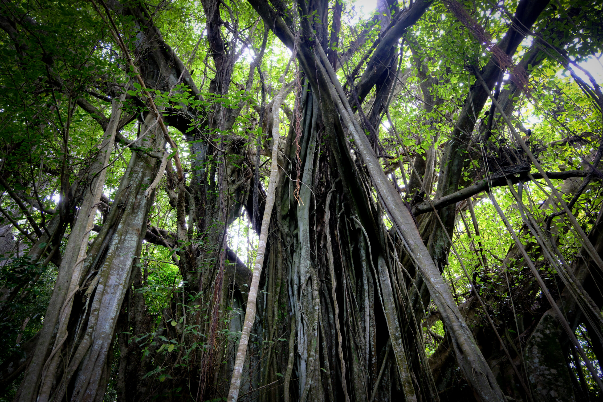
The banyan tree is not subtle once you are close enough. It does not look like one tree. It looks like an entire section of the jungle decided to become one organism. Roots coming down from branches overhead, connecting back into the ground, forming a structure that is simultaneously a tree and a room and something that feels genuinely ancient.
I could not tell you how wide it spans because you cannot see the edges clearly through the canopy, but standing underneath it, the scale is unlike anything I have seen outside of a very large banyan I once saw in Bali, and this one has a different quality to it entirely. Older. Quieter. More intentional somehow.
I did not see the carved boulder that is supposed to be nearby. My feet were hurting, my toenails had caught on rocks a couple of times during the boulder sections because I was in Chacos, and I was soaking wet from sweat. I stayed long enough to take it in, took some photos, and started back down.


The Way Down
On the descent I ran into the same local man I had met near the Marae area. I told him I found the tree. He smiled. We talked for a minute. He was planting banana palms in a big cleared grass area, forty of them in a ring, probably laying the groundwork for a house site at some point.
He confirmed the road below connects all the way down to the main perimeter road. I followed it down, gravel turning to pavement, passing the same guy I had seen earlier on the scooter, giving a wave. Got back to the main road, turned right, took a photo of the tsunami evacuation route sign, and walked back to the car.
Changed shirts in the parking lot. Sat there for a minute. Three avocados in my bag that were not even ripe yet, a full day of wrong turns and dead ends behind me, and all I had to show for it was one very large tree in the middle of the jungle. It was enough.
Should You Do This Without a Guide?
What I can do with this post is get you to the banyan tree. I can show you where the Marae site appears on the Strava heat map and AllTrails route. I can tell you which dead ends to skip, where the entry point is, and what the path looks like once you find it. That part I earned the hard way so you do not have to.
What I cannot give you is everything else. The story of why this valley is called the Valley of the Kings. The significance of the royal burials inside the tree roots. What the petroglyph actually represents and what it meant to the people who carved it.
The medicinal plants growing along the trail and what the ancestors used them for. The cultural weight of the Marae and what was lost when contractors removed its stones. That knowledge lives with people who were born into it, who have spent years studying it, who can walk you through that jungle and make it feel like something you will carry home with you.
This post can get your boots on the right path. A local expert can make the whole thing mean something.

Who to Book for the Valley of the Kings Hike
These are the guides who know this area. All three are locals with deep knowledge of the island.
Django Edwards (Bora Hiking Explorer) is the name that came up unprompted from a local I met on the trail. He was named Nat Geo Best of the World 2024 and runs cultural hikes, WWII site tours, and jungle trails. Find him on Facebook at facebook.com/HikewithDjango. Based on what people in the Bora Bora Facebook travel groups say, response times can be slow so message him as early as possible.
Azdine Oualid (Polynesia Island Tours) is the guide featured in the Bora Bora Insider write-up on this exact hike. He has been leading groups through the Faanui valley since 2006 and is the person who originally discovered and documented the Marae site. Phone: 29.66.60 or 67.56.02. Email: polynesiaislandtours@mail.pf. Available any day except Sunday, dry season only.
Wesley (Tahitian Hiking) focuses on cultural and scenic hikes with a strong emphasis on safety. WhatsApp: +689 89 26 68 11. Email: tahitianhiking@gmail.com. Facebook: Tahitian Hiking.
Hike Stats
| Stat | Details |
|---|---|
| Distance | 4.80 miles |
| Elevation Gain | 1,259 ft |
| Moving Time | 2 hrs 18 min |
| Steps | 11,044 |
| Calories | 841 |
| Water Used | Approximately 2.5 liters |
| Conditions | Post-rain, muddy, overgrown in sections |
Note: These stats include all dead ends and wrong turns. The actual trail to the banyan tree is significantly shorter.
What to Bring
Bring more water than you think. Two liters minimum, three is better especially if conditions are hot or you go off trail. Wear actual hiking shoes or trail runners, not sandals. Long pants protect you from overgrown brush in the upper sections. Bring your phone fully charged with AllTrails and Strava. Snacks are a good idea, I skipped them and regretted it by hour two. Bug spray is worth having.
Is the Valley of the Kings Worth It?
The tree alone is worth it if you are the kind of person who does not need a sign and a paved path to find meaning in something. Standing underneath Tumu Ora, knowing what it is and what has happened there over centuries, is a genuinely affecting experience even without a guide explaining it.
But this is not a hike with epic ridge views or a clean summit reward. There are no sweeping lagoon panoramas. You are in a valley, in the jungle, looking for something that does not announce itself. The reward is cultural and spiritual, not visual. Know what you are signing up for before you go.
If you want the views, the Mount Mataihua hike starts from the same parking lot and gives you a full 360 of the island including a distant look at the banyan tree area from above. If you want the cultural depth of the Faanui valley, book a guide and do it right.

| Quick Facts | Detail |
|---|---|
| Location | Faanui village, Bora Bora, French Polynesia |
| Trail Name | Faanui Marae / Valley of the Kings |
| Distance | 4.80 miles (including all dead ends) |
| Elevation Gain | 1,259 ft |
| Moving Time | 2 hours 18 minutes |
| Steps | 11,044 |
| Calories | 841 |
| Difficulty | Moderate to hard (route-finding is the real challenge) |
| Trail Markers | None |
| Parking | Large lot in front of Faanui church, near the covered gymnasium |
| Best For | Cultural history seekers, experienced hikers comfortable off trail |
| Not Recommended For | First-timers, anyone without a fully charged phone and GPS app |
| Guide Recommended | Yes, especially to find the Marae and get the full cultural story |
More Bora Bora Hikes Worth Adding to Your List
- Hiking in Bora Bora: Free Self-Guided Trails, Ridge Views, and When You Need a Guide
- Valley of the Kings Bora Bora: Finding the Sacred Banyan Tree Solo
- Mount Mataihua Hike Bora Bora: The Rope-Assisted Ridge Climb Most Visitors Never Attempt
- The WWII Guns at Faanui: Bora Bora’s Free Cannon Hike Most Tourists Skip
- Hiking Mount Mata Pupu in Bora Bora: A Short Ridge Hike With Incredible Lagoon Views
- Hiking Arete de Matira in Bora Bora: A Family Friendly Ridge With Incredible Views
Frequently Asked Questions
Is the Valley of the Kings hike free?
Yes. There is no entrance fee. You will be crossing private land in sections so be respectful, ask permission when someone is present, and pack out everything you bring in.
How long does the Valley of the Kings hike take?
Budget a full half day minimum. With dead ends, the solo route-finding attempt took the better part of a morning. A guided hike will be more direct but the valley and the cultural stops take time.
Can you do the Valley of the Kings hike without a guide?
You can find the banyan tree solo if you are experienced and patient, but you will miss the Marae, the petroglyph, and the entire cultural story of the site without a guide. For the full experience, book one.
What is the Marae in Faanui?
A Marae is a sacred Polynesian ceremonial and temple site. The Faanui Marae is one of the oldest and most significant on Bora Bora, featuring stone platforms and an anthropomorphic figure that predates the Easter Island moai. The site has unfortunately been partially damaged by construction activity over the years.
What is the Tumu Ora banyan tree?
Tumu Ora means Tree of Life in Tahitian. It is one of the largest banyan trees in French Polynesia and served as a royal burial site for the kings of Bora Bora. The tree inspired elements of the film Avatar. James Cameron spent several hours at the site during research for the film.
What shoes should I wear for this hike?
Trail runners or hiking shoes. Not sandals. The terrain includes mud, volcanic rock, boulder scrambling, and off-trail sections with roots and uneven ground.
Is there parking at the Faanui valley trailhead?
Yes. Park in the lot in front of the Faanui church, next to the covered gymnasium. It is a proper lot, not a roadside spot.


Leave a Reply


Planning
Tips
Destinations
Oceania
North America
Europe
Asia
Bali
Japan
Korea
Malaysia
singapore
Thailand
Vietnam
France
U.K.
Germany
Canada
Mexico
usa
French Polynesia
Micronesia
Hawaii
Guam
Indonesia
All Travel Blogs
Destinations
Planning
Tips
Destinations
Travel Tips
Planning
About us
Hotels
via Booking.com


Car Rental
Book a Bus/Train/Transfer
Find Cheap Flights
Get ESIM or SIM Card
Easy Currency Exchange
Book Tours & Attractions
Get Travel Insurance
via Discover Cars
via Skyscanner
via 12Go
via Wise
via Viator
via Visitors Coverage
via SimOptions
Destinations
Planning
Tips
All Categories
Travel Tips
Worldschooling
Digital Nomad
Travel Hacking
Travel with kids
Lifestyle
Military Travel
Packing
All Travel Tips
Tech
