


saltyvagabonds
Saltyvagabonds
Destinations

Asia
Bali
Japan
Korea
Malaysia
singapore
Thailand
Vietnam
Europe
Germany
France
U.K.
North America
Canada
Mexico
Oceania
Polynesia
Micronesia
Hawaii
Guam
Indonesia
All Travel Blogs
Travel Tips
Planning
About us
usa
Destinations
Travel Tips
Planning
About us
All Categories
Travel Tips
Worldschooling
Digital Nomad
Travel Hacking
Travel with kids
Lifestyle
Military Travel
Packing
All Travel Tips
Tech


Travel Hacking with
Chase Points
Military Space A Flights
Guide


Hiking Arete de Matira in Bora Bora: A Family Friendly Ridge With Incredible Views
Hiking Arete de Matira in Bora Bora takes you off the beaches and up a volcanic ridgeline with sweeping views of Matira Beach, the lagoon, and the outer reef. In this guide we share how to find the trailhead, what the climb is like, and why this is one of the most underrated viewpoints on the island.

If you click on links we provide, we may receive compensation.


The Edit: Hiking Arete de Matira is one of the most scenic and accessible ridge hikes in Bora Bora. The route follows a gated TV tower service road up from the Matira Peninsula before transitioning onto a volcanic ridgeline with views overlooking Matira Beach, the lagoon, and the island of Maupiti in the distance. This guide covers how to find the trailhead, what the trail conditions are like, local cultural details you won’t find in other guides, and why this hike is a better choice than Mount Mata Pupu for most visitors.

How This Hike Happened
I had already done Mount Mata Pupu solo by the time our Airbnb host Haunui and I got around to this one.
Haunui had mentioned a few different hikes around the island while we were out snorkeling together, offering to show us around whenever we were ready. He described Arete de Matira as the easier option, something the whole family could do. They ended up not wanting to come along, so it turned into just the two of us.
The day came together pretty casually. He stopped by the house to take out the trash and I mentioned I had a phone call from 12 to 1 but was free after. He texted later and said he could make it work, so we went at 4.
He picked me up in his work truck and we headed south along the perimeter road that circles the island, passing the Mount Mata Pupu turnoff before continuing down toward the Matira side.
Finding the Trailhead
The starting point for this hike is just before the famous Bloody Mary’s restaurant, which is currently being renovated as part of a new overwater bungalow resort development.
The landmark you’re looking for is a green electrical box along the roadside. There’s a small sandy pull-off area nearby where you can park, similar to a lot of the other roadside trailheads around Bora Bora.
When we pulled up, the spot actually looked familiar. About a week earlier we had stopped in the same area because a local fisherman had set up a rack along the road selling fish he and his son had caught while spearfishing that morning. He lives right there on that corner, so it’s a useful reference point.
From the parking area, you cross the road and head toward what looks like a private driveway. It genuinely feels like you might be walking onto someone’s property, but it’s actually a dirt service road leading up to the island’s TV tower and is a tsunami evacuation route number 17. There are a couple of homes along the lower section of the road, including the fisherman’s house, so you’ll pass them as you start the climb.


Starting the Climb
After a short walk you’ll reach a chain stretched across the road near the second house on the right. Beside the chain there’s a small opening in the vegetation where hikers can pass through.
This is where the service road really begins.
The road is closed to vehicles, which is what keeps it in decent shape. Because nobody drives up it regularly, the surface holds together better than some of the other roads around the island. It’s wide enough that it still feels manageable even as it gets steep.
As we started climbing, Haunui pointed out different plants growing along the hillside. One of the most common is the pandanus tree, which produces a fruit locals sometimes process into juice. The leaves show up all over Bora Bora too, used for the traditional thatched-style roofing on resort bungalows throughout the island.
A couple of neighborhood dogs wandered by early in the climb. Unlike the dogs near the Mount Mata Pupu trail, these ones were calm and completely unbothered.

The Wild Pineapple Patch
One of the more surprising things along the hike was a small patch of pineapple plants growing along the road.
At first glance they look exactly like grass. If you don’t know what you’re looking for, you’d walk right past them. It’s only once you notice the distinctive leaves that it clicks.
Haunui explained that locals sometimes plant crops in remote parts of the island rather than only in their yards. Groceries in Bora Bora are expensive because most things are imported from other islands or shipped in from overseas. A Hinano beer brewed right there in Tahiti costs around $3 for a 12-ounce can, compared to maybe a dollar in the United States or a fraction of that in Mexico. Food costs add up fast.
Because of that, some families plant things like pineapples, bananas, taro, sweet potatoes, and coconuts in spots scattered around the island and come back to harvest them later. Pineapples take close to two years to produce fruit, so it’s a long game.
The patch we passed had around 30 plants, none of them producing yet. Haunui figured the heavy tree cover overhead was limiting sunlight, and that clearing some of the surrounding brush would likely get them going. He mentioned there’s a much larger pineapple plantation over on Moorea as a point of comparison.

Climbing Toward the Ridge
Past the pineapple patch, the road continues uphill and the environment gradually changes.
A more rustic house sits up the road a bit, catching rainwater into reservoir tanks. Beyond that, the tree coverage starts to thin out and the road gets noticeably steeper.
This is the section where you feel yourself approaching the actual crest of the ridge.
An arete is essentially the spine of a volcanic cone, and that’s exactly what this is. You’re climbing up the inner slope of Bora Bora’s ancient volcano toward the narrow ridge that runs along the top. The views start opening up behind you as the vegetation drops away.


The TV Tower Viewpoint
At the top of the service road sits the island’s TV tower, and even if you stopped here and turned around, the trip would be worth it.
From the tower you’re looking roughly west and northwest across the lagoon. On a clear day you can see:
- The island of To’opua, where the Conrad Bora Bora Nui resort sits
- The turquoise lagoon spreading out toward the reef
- Maupiti in the distance, another island in the Society Islands group with its own beautiful lagoon
Maupiti is smaller and far more laid-back than Bora Bora. The ferries run out there from Bora Bora, go to Maupiti, and then turn around and come back the following day.
On the way down, Haunui mentioned that this viewpoint is actually a solid sunset spot. The road is wide and easy to follow, so there’s no real concern about navigating technical terrain in fading light. Watching the sun drop toward Maupiti from up here would be something.


Hiking the Arete Ridge
From the TV tower, a narrower trail continues along the ridgeline itself.
The terrain changes noticeably here. You’re no longer on a maintained road. Instead the trail winds through ironwood trees, which look similar to pine trees and drop small cone-like seeds onto the path. Volcanic rocks and boulders are scattered throughout, and the trail dips and climbs gently as it follows the spine of the ridge.
It’s not technical, but you’re clearly on the edge of the mountain with steep slopes falling away on both sides.
We walked about fifteen to twenty minutes along the ridge before reaching a small lookout point that is the top of Rufau mountain. One direction continued along the main arete. Another branched off toward the Matira peninsula side.
That’s where we stopped, got the drone out, and took a few quick clips.


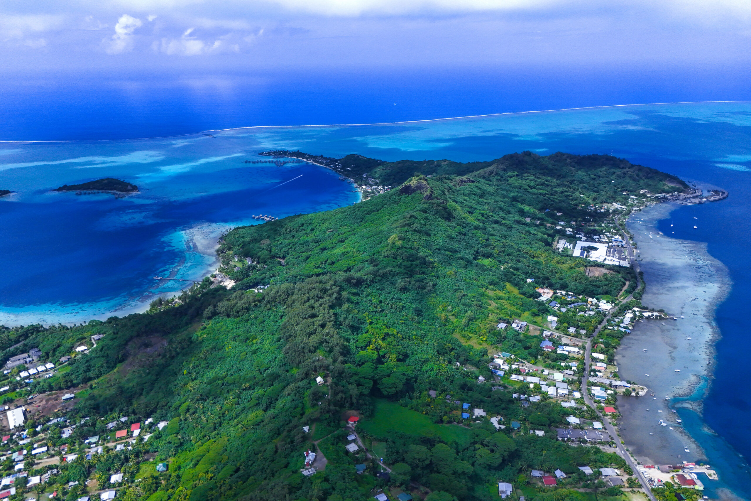
The Views Over Matira Beach
The Rufau mountain outlook turned out to be one of the best viewpoints I’ve found on the island.
From up there you can see:
- Matira Beach laid out below
- The turquoise shallows of the lagoon surrounding the peninsula
- The deeper blue of the ocean beyond the reef
- The area where Club Med Bora Bora used to operate before it closed
- Overwater bungalows along the Matira side
The color contrast between the lagoon and the open ocean is genuinely unreal from this elevation. Photos don’t fully capture how layered the blues are when you’re looking down at it from the ridge.
While we were up there, a trail runner passed by. Then a whole family came up the trail, kids around 10 or younger, completely unbothered, just out for a hike. It was a good reminder that this trail is a different category than Mata Pupu.

How Far Can You Actually Go?
We stopped at the Rufau viewpoint, which you can see marked on AllTrails, and turned around from there. Not because the trail ends there, but purely because of daylight and time. If you start earlier in the day you can cover significantly more ground along the spine past Rufau.
Haunui explained that the trail used to extend all the way toward the Mount Mata Pupu side of the island, eventually connecting to the service road and overlook area over there. That would have made for an incredible full ridge traverse with sweeping views of the Blue Lagoon, the barrier islands, and both sides of Bora Bora at once.
That connection is no longer accessible.
The trail crosses private land where local families grow food, and some visitors weren’t respectful about it. Crops were being stolen, plants were being trampled, and trash was being left behind. The landowners eventually closed that section off, and honestly it’s hard to blame them.
So the trail does continue past Rufau, and I highly recommend continuing to Vero Hiti, which you can see marked on AllTrails. But it eventually dead ends before reaching the Mata Pupu side. To get to that overlook area from this trail, you’d have to descend off the ridge, navigate around via roads, and climb back up on the other side.
If you’re using AllTrails, the ridge looks like it connects all the way through. It doesn’t anymore. Worth knowing before you plan a big traverse day.

The Avocado Tree on the Way Down
On the descent we stopped at a switchback where a large avocado tree was growing alongside the road.
The fruit on it was massive, almost the size of a small melon. These aren’t the bumpy Hass avocados you’re used to seeing. This variety has smoother, waxier skin and turns a purplish color when ripe. A few of the ones near the top of the tree were just starting to show that color. The ones within reach were still weeks out.
Haunui whistled toward the nearby property in a casual, not-really-calling kind of way, and the owner came out after a moment. They chatted for a few minutes in what sounded like Tahitian, not French, pointing at the tree and the fruit.
Turns out the tree belonged to that family.
It was one of those small moments that sticks with you. The guy mentioned he had gotten one ripe avocado the other day and was saving it for breakfast the next morning. These things take time, and they matter to people.
That applies to everything growing along the trail. The pineapples, the bananas, the coconuts along the road. They look like they’re just growing wild, but a lot of it belongs to someone. When food is this expensive on the island, picking something off a tree isn’t a harmless thing to do.
We finished the descent, passed back through the chain gate, said a quick hello to the fisherman and his son outside their house, and drove back.

Trail Stats
| Stat | Details |
|---|---|
| Distance | 1.43 miles |
| Elevation Gain | 506 ft |
| Moving Time | 53:02 |
| Steps | 3,988 |
| Calories | 251 Cal |
Most of the elevation gain comes from the initial climb up the service road. Once you hit the ridge, the trail rolls more gradually with gentle ups and downs along the spine.

Is the Arete de Matira Hike Worth It?
Yes, and for most people visiting Bora Bora it’s probably the better hike compared to Mount Mata Pupu.
Mata Pupu has incredible summit views, but parts of that trail are legitimately sketchy. The rock scramble section, the wet volcanic descent, the narrow ridgeline approach. It’s not for everyone.
Arete de Matira is different.
The wide service road makes the bulk of the climb manageable and much less intimidating. There are no rope sections, no exposed scrambling, nothing that requires you to question your footing. We saw multiple young kids hiking it without any trouble.
If you want great views of the lagoon and Matira without feeling like you’re taking on something above your comfort level, this is the one to do.
If you want the raw, more challenging experience and don’t mind some exposure, Mata Pupu delivers more on that front.
Both are worth it. This one is just more accessible.
| Quick facts | Detail |
|---|---|
| Location | Bora Bora, French Polynesia |
| Trail Name | Arete de Matira |
| Distance | 1.43 miles round trip (partial route) |
| Elevation Gain | 506 ft |
| Moving Time | ~53 minutes |
| Difficulty | Easy to moderate |
| Trail Type | Out and back |
| Trail Features | Service road climb, volcanic ridgeline, ironwood forest |
| Best Views | Matira Beach, Bora Bora lagoon, To’opua island, Maupiti |
| Trailhead Landmark | Green electrical box just before Bloody Mary’s restaurant |
| Parking | Small sandy pull-off along the roadside |
| Family Friendly | Yes, more so than Mount Mata Pupu |
| Trail Conditions | Can be slippery after rain |
| Best Time to Go | Afternoon for ridge views, late afternoon for sunset at the TV tower |
More Bora Bora Hikes Worth Adding to Your List
- Hiking in Bora Bora: Free Self-Guided Trails, Ridge Views, and When You Need a Guide
- Valley of the Kings Bora Bora: Finding the Sacred Banyan Tree Solo
- Mount Mataihua Hike Bora Bora: The Rope-Assisted Ridge Climb Most Visitors Never Attempt
- The WWII Guns at Faanui: Bora Bora’s Free Cannon Hike Most Tourists Skip
- Hiking Mount Mata Pupu in Bora Bora: A Short Ridge Hike With Incredible Lagoon Views
- Hiking Arete de Matira in Bora Bora: A Family Friendly Ridge With Incredible Views
Frequently Asked Questions About Hiking the Arete de Matira Hike
Is the Arete de Matira hike free?
Yes, there is no entrance fee. The service road is on private land but hikers are welcome to walk it.
Is the Arete de Matira hike family friendly?
Yes, especially the section up to the TV tower. The service road is wide and manageable. The ridgeline trail past the tower is still accessible but more natural terrain.
How long does the Arete de Matira hike take?
Our partial route took just under an hour of moving time. Budget 2 to 3 hours total if you want time at the viewpoints.
Can you hike the full ridge?
You can hike a good portion of it, but the section that historically connected toward Mount Mata Pupu is now closed due to private property restrictions.
What app should I use for the Arete de Matira hike?
AllTrails shows the trail. The waypoint “Rufau” marks the ridge viewpoint area. Bring a fully charged phone.
What should I wear?
Grippy shoes are important, especially after rain when the trail gets slippery. Lightweight, breathable clothing and sunscreen are a must.
Is there parking at the trailhead?
Yes, there is a small sandy pull-off along the roadside near the green electrical box just before Bloody Mary’s restaurant.


Leave a Reply


Planning
Tips
Destinations
Oceania
North America
Europe
Asia
Bali
Japan
Korea
Malaysia
singapore
Thailand
Vietnam
France
U.K.
Germany
Canada
Mexico
usa
French Polynesia
Micronesia
Hawaii
Guam
Indonesia
All Travel Blogs
Destinations
Planning
Tips
Destinations
Travel Tips
Planning
About us
Hotels
via Booking.com


Car Rental
Book a Bus/Train/Transfer
Find Cheap Flights
Get ESIM or SIM Card
Easy Currency Exchange
Book Tours & Attractions
Get Travel Insurance
via Discover Cars
via Skyscanner
via 12Go
via Wise
via Viator
via Visitors Coverage
via SimOptions
Destinations
Planning
Tips
All Categories
Travel Tips
Worldschooling
Digital Nomad
Travel Hacking
Travel with kids
Lifestyle
Military Travel
Packing
All Travel Tips
Tech
